Wesley Chapel
BACKPACKING INSTITUTE
What's New!
Florida Trail Ocala National Forest
Clearwater Lake to Farles Lake Trip Log, October, 2018
Featured Backpacking Trips
05/01/18 - Joyce Kilmer Slickrock, Hangover Mt. Loop, North Carolina
04/01/18 - Panthertown, Bonas Defeat Gorge, North Carolina
03/01/18 - Panthertown, Cold Mountain, North Carolina
02/01/18 - Chattooga River Trail, Upper Section, North & South Carolina
01/01/18 - Florida Trail, Suwannee River East & West, Florida
(click "Expeditions" at the top of the page for trip logs for these
hikes)
Chattooga River Trail
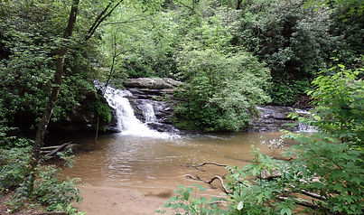
Licklog Falls
Overview
The Chattooga River Trail (CRT) parallels the Chattooga River for about 45 miles, from near its origin close to Cashiers, North Carolina to the Highway 76 Bridge on the Georgia/South Carolina border. In terms of backpacking opportunities in the southeast, it’s hard to find the words to describe what a true gem the CRT is. As you work your way down the trail, you get completely immersed in a watery ecosystem; from the Chattooga River itself with its many rapids and swimming spots to the numerous springs, tributaries, and waterfalls, and all of it in such pristine condition, you almost wouldn’t be surprised if a Cherokee hunting party appeared around the next bend.
Even though the CRT is often directly adjacent to the river for long stretches, it sometimes ranges high above on the surrounding ridges before descending back to the river. Unfortunately, even from these higher elevations the green canopy is so dense that views of the Chattooga River Valley are all but non-existent. The diversity of terrain is one of the reasons the CRT is so interesting and occasionally somewhat challenging. Another reason is the potential in certain areas to take side trails that go to interesting places and then allow you to loop back to the CRT to avoid backtracking. The CRT crosses the Ellicott Rock Wilderness which straddles Georgia, North Carolina and South Carolina and the Chattahoochee, Nantahala, and Sumter National Forests.
In 1974, the Chattooga River was protected along a 15,432-acre corridor as a national Wild and Scenic River. For much of this distance there is a quarter mile “protected” corridor of National Forest on both sides of the river, within which the CRT mostly winds its way. In theory, no roads or development of any kind are allowed within this corridor, but in a couple of spots in the lower sections, some of the locals don’t pay much attention to this rule. Another concern is the extreme erosion caused by horses along stretches of the trail on the Georgia side near Earl’s Ford.
The WCBI hiked this trail over two separate trips; the lower section in September of 2013 from the Highway 28 bridge to the Hwy 76 bridge (approximately 20 miles) and the upper section in September 2014 from the trailhead on Whiteside Cove Road in North Carolina to the Highway 28 bridge (approximately 24.5 miles). By taking some of the numerous side trails, considerable additional mileage was added to each trip. The Upper Section is lightly travelled while the lower section is busier due to horseback riding traffic.


Left: The Unfinished Stumphouse Railroad Tunnel. Right: The Unsuspecting City Slickers Soon to be Stalked by Some Very Uncivilized Country Boys.
The character of the two sections is somewhat different. At the start of the upper section, the river is near its source so it’s not much more than a creek. After the first 6.25 miles at Bull Pen Road, someone apparently forgot to build a section of the CRT because there’s a gap in the trail of about two miles. This is dealt with by leaving the CRT at Bull Pen Road and hiking up it for about 0.75 miles to reach the Ellicott Rock trail, which descends for several miles back to the Chattooga River and the CRT. Here the river is forded near historic Ellicott Rock. Further along are numerous waterfalls on tributary streams, an interesting side trail to the Walhalla State Fish Hatchery that allows a return to the CRT via the Foothills Trail, a short side trail to Big Bend Falls (a major rapid on the river), Burrell’s Ford hike-in campground, and more waterfalls.
The friendly creek in the upper section morphs into a no-nonsense river in the lower section, which can be down-right dangerous at high water. The area around Earl’s Ford is a horseback riding Mecca where there’s a somewhat confusing and unmarked trail network that weaves its way back and forth across the river and is easily accessible from the CRT. It’s easy to get lost in there, but with a compass and a good map, it’s great fun to puzzle out. If you take these trails you can extend your mileage and enjoyment of the area, especially if you ford the river at the designated spots. However, doing this when the river is up, especially when encumbered with a backpack, is a great way to permanently swim with the fishes. Further downstream is the iron bridge crossing of Warwoman Creek, the beach at Earl’s Ford, and the side trail to Dick’s Creek Falls and Dick’s Creek Ledge; an especially scenic river-spanning rapid.
Natural History
Sources for the following information: A Guide to the Chattooga River Butch Clay (Menasha Ridge Press, 2012) and the New Georgia Encyclopedia (online)
Geology
The headwaters of the Chattooga River are located in the Blue Ridge Mountains, which is just a small piece of the Appalachian Mountain Chain created hundreds of millions of years ago when the African and North American tectonic plates collided. Geologists believe the river may have made a direction change at some point in its history. Originally, it probably flowed southwesterly into the Chattahoochee River and on to the Gulf of Mexico, but at some point, in a process known as stream capture, the Savannah River eroded its northern headland over many millions of years until it intersected the Chattooga and diverted it to the Atlantic Ocean. The rocks in the riverbed fell from the surrounding ridges, but during heavy rainfall events, high water and powerful currents move them downstream, taking other rocks and debris with them. This happened during Hurricane Ivan in 2004 when the river reached its highest recorded flow of around 28,000 cubic feet per second (754 million gallons per hour), which is about the typical flow of the Colorado River in the Grand Canyon.
Human History
Native Americans
The first humans to see the Chattooga River were Paleo Native Americans who arrived in the region around 12,000 years ago. These folks lived in primitive camps, hunted game, gathered nuts, roots, and berries, and left little trace of themselves. Next came the Cherokees who at their peak, occupied around 40,000 square miles of mountainous land over what are now the southeastern states. The Cherokees had a rich spiritual life, believing that if the streams were followed back far enough, the underworld of spirit beings would eventually be reached. The sounds made by rapids on the rivers were the voice of Long Man the river god who spoke a language only spiritual people could understand. The Cherokees believed the mountains were made by the great grandfather buzzard who flew down to dry the earth with his giant wings. The updraft of the wings created mountains while the downdraft created valleys.
Chattooga, or Tsatugi, has a variety of meanings, including: "he drank by sips," or "he has crossed the stream and come out upon the other side." Early European explorers and travelers and recent archaeologists, recorded the existence of Chattooga Town near the confluence of the Chattooga River and the West Fork of the Chattooga River. English maps note the town's location, and a census taken in 1721 counted approximately ninety people living in the village. Evidence indicates that Cherokees resided in the town, possibly as early as the late 1600s until about the mid-1700s, and constructed numerous structures, including a council-townhouse, pavilions, storage buildings, and other seasonal-use structures. The river bottom's rich soils were ideal for growing corn, beans, and squash.
The Cherokees initially had good relations with the British and fought with them against the French in the French and Indian War. They also chose to fight with the British during the American Revolution and this unfortunate decision forced them to into giving up more and more land. By the conclusion of the war, the Cherokees had abandoned the Chattooga watershed and their removal from Georgia became formal policy in 1838.
White Settlers
Europeans entered the Chattooga River watershed primarily from South Carolina via trade routes that originated in Augusta and Charleston. English naturalist William Bartram noted evidence of former Cherokee villages like Chattooga Town but more often described the Chattooga watershed's incredible flora and fauna when crossing the "delightful river" in the vicinity of Warwoman Creek in 1775.
After the American Revolution, veterans received land grants that spurred settlement in the region. An important 1820s establishment in the watershed was the Russell homestead. Located just downriver from the former Chattooga Town site, this property was a farm and tavern. Travelers crossed the Chattooga River near the Russell house on their way to Highlands, North Carolina. In 1852, businessmen from Charleston, Knoxville, and Cincinnati, planned to connect their cities via the Blue Ridge Railroad. The proposed 195-mile line would have crossed the Chattooga where Dick's Creek enters the river, thereby connecting Clayton, Georgia, by rail with Walhalla, South Carolina. However, rising costs associated with extensive tunnel engineering and the economic collapse caused by the Civil War halted completion of the railroad. The unfinished Stumphouse tunnel not far from the Chattooga River is all that remains of the venture.
Logging
Between the end of the Civil War and the early 1900s, logging in the north Georgia mountains shifted from a localized and unregulated activity to a federally organized and international business. Local timber operators purchased timber rights and property in the Chattooga River watershed after 1902. The loggers relied on techniques like splash dams and technology that damaged the land more drastically than previous timbering activity. To counter these impacts on a national level, the U.S. Congress passed the Weeks Act in 1911, which empowered the U.S. Forest Service to begin purchasing cutover private lands for the purpose of controlling soil erosion, replanting timber, and maintaining navigable waterways. The founding land purchases established the Chattooga River watershed's national forests.
Wild and Scenic River Designation
The 1968 Wild and Scenic Rivers Act named the Chattooga River eligible for inclusion in a new national water conservation system. The new Wild and Scenic River system was designed to conserve and restore unique rivers across the country. Protecting the Chattooga River served to offset extensive dam construction in many southern watersheds. On May 10, 1974, Congress designated the Chattooga a Wild and Scenic River after a decade-long study managed by the Forest Service. Of the Chattooga's 57 protected miles, 40 are classified as wild, two and a half as scenic, and nearly 15 as recreational.
The Chattooga and the Movies
Portions of the popular movie Deliverance, released in 1972 and starring Burt Reynolds, were filmed on the Chattooga River. The film is remembered for the music scene where the hit song “Dueling Banjos” was played by one of the ill-fated canoeists from the city and a local country boy during an unlikely jam session and for its disturbing male rape scene. To this day that scene is a strong motivator for city folk to stay out of the woods and may explain the scarcity of backpackers along this amazing trail. It also inspired the famous souvenir T-shirt, highly prized by Chattooga River rafters, that says: “Paddle Faster, I hear Banjo Music”. In 2008, Deliverance
was selected for preservation in the United States National Film Registry by the Library of Congress as being "culturally, historically, or aesthetically significant". Ok, the aesthetic part I get, but can a movie that Burt Reynolds starred in be culturally and historically significant?
Maps and Information
The maps provided in the trip logs were developed by a rank amateur cartographer (Doc Livingston) and are kinda-sorta accurate. They are only intended to help you get the general lay-of-the-land and if taken on the trail and relied on completely, you may have a much more intense adventure than you bargained for.

Scenic Chattooga River

Crossing the Chattooga River
By far the best map of the CRT is (or was) produced by the U.S Forest Service. On the front panel is the title “Chattooga – National Wild and Scenic River” and a picture of three backpackers on a big boulder on the side of the river. In tiny print at the bottom of one of the panels is: Recreation Guide R8-RG 177, December 1994. Although the map is a guide for river runners, it provides a lot of detail for the CRT. You’ll get a chuckle out of the photographs that time warp you back to the bad old days of the 1970s when backpacks had exterior aluminum-frames and kayakers struggled down the river in monster fiberglass boats held together with wraps of duct tape. This map is almost certainly out-of-print, which is a shame because for nearly 20 years Doc stowed it in his kayak and backpack to navigate the river and the CRT.
There are a number of sites on line that provide maps and descriptions of portions of the CRT, although none have the level of detail of the Forest Service Map described above. Just type in “Chattooga River Trail and see what you get.
Another great resource that was borrowed from liberally for this description is “A Guide to the Chattooga River” by Butch Clay (Menasha Ridge Press, 2012). This publication provides information on the river and its natural and human history and is still in print.
Shuttles
The Foothills Trail Association’s web site (foothillstrail.org) has information about shuttle services for the Foothills Trail. The page contains contact information for shuttle drivers, some of whom will provide shuttles for the Chattooga River Trail. There are both volunteer shuttle drivers and commercial drivers available to help with the logistics of your hike. Volunteers are “hikers helping hikers”; they do not charge set fees but should be reimbursed fairly for the number of miles traveled.